SR 20 Widening/Intersections Improvement Project

FAST FACTS

GDOT Project #: 0007836
Type: Reconstruction/Rehabilitation
Project Length: 19.4 miles
Affected Counties: Cherokee & Bartow
Condemning Authority: GDOT
Estimated Affected Parcels: 200
Estimated Cost: $168,540,675
Right-of-Way Funds: $35,828,000

Descriptions

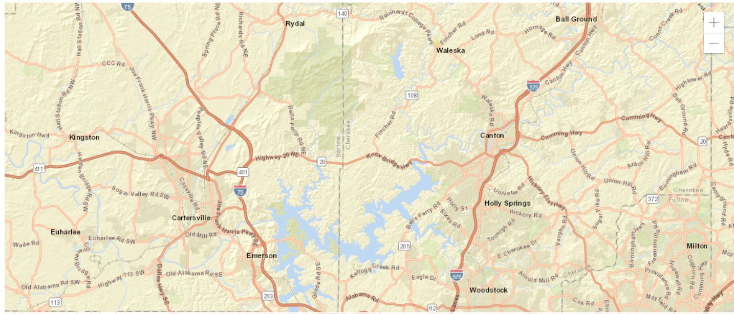
SR 20 is a major east-west thoroughfare on the northern edge of Metropolitan Atlanta which is experiencing congestion, limited mobility, and safety issues. GDOT Project #0007836 involves the SR 20 interchange with I-75 in Bartow County and the interchange with I-575 in Cherokee County, as well as 36 intersections and commercial developments along the 19.4 miles of SR 20 between I-75 (Cartersville) and I-575 (Canton). This project will widen SR 20 linking Cartersville and Canton from two to four lanes with a median. Major structures include widening of existing bridges over Stamp and Boston Creeks and replacement of Knox Bridge over Lake Allatoona/Etowah River.

There are numerous intersections along the corridor that do not meet current design standards. Several of the major intersections have extreme angles or steep horizontal/vertical curves that limit the visibility of the drivers. Some of these locations have higher than average accident rates, and crash severity analysis shows that accidents along the corridor tend to be severe. Major intersections along the corridor include: SR 294, Bells Ferry Road/Wilderness Camp Road, Fincher Road/Highway 108, Fields Landing Drive, River Green Avenue/Butterworth Road, Marietta Highway/Highway 140, and Hickory Flat Highway/Highway 140. GDOT claims that improvements to access control and horizontal/vertical curvature have the potential to reduce the number and severity of accidents at these intersections.

Some of the development along the corridor includes residential streets and neighborhoods, the Vulcan Quarry, the Georgia National Cemetery, Knox Elementary School, River Greene Academy, and Teasley Middle School.

The cost estimate breakdown for project #0007836 follows:

ACTIVITY YEAR COST ESTIMATE
Scoping 2013 $ 1,950,000
Preliminary Engineering 2016 $ 4,761,334
Preliminary Engineering 2018 $ 4,063,753
Right of Way Acquisition 2024 $ 35,828,000
Utilities Relocation 2026-2030 $ 4,507,750
Construction 2026-2030 $117,429,838
TOTAL
$168,540,675

The improvements may accommodate increased traffic and reduced accidents, but property owners on the planned route should be aware of the changes being made and how their properties may be affected by both the process, construction, and resulting traffic patterns.

Business and homeowner concerns

As usual, property owners stand to lose some or all of their property when the government decides it’s needed for the public good. GDOT will make offers, but it’s important to remember that those offers may be low. Like any other buyer, GDOT wants to buy as affordably as possible, and it may not include things like relocation expenses or lost business income in the initial offer. You must fight for that compensation!

There may be drainage and utility easements taken with Project #0007836, which can be very tricky from a property rights standpoint. In addition, there are also historic properties, streams and wetlands, and residences and businesses that may require context-sensitive solutions to minimize the impact of this project.

Your property may be significantly affected by these changes. Contact us if your property is in the path of this SR 20 widening and intersection improvements project between I-75 in Bartow County and I-575 in Cherokee County, and we can discuss your circumstances.

What to Do if Your Property Is Affected

Even though the government can take your land, you still have rights. GDOT has set aside an estimated $35,828,000 for right-of-way acquisition for this project – but there may be surrounding circumstances that could complicate matters.

You have the right to fair compensation. Remember: the initial offer is just the beginning as long as you do not accept it. You can fight for more. Call 1-888-391-1339 or contact us as soon as possible for a complimentary case evaluation.

We do not take an attorney’s fee unless we increase the government’s offer, and our fee only comes from the increased amount – this is our “no fee guarantee.” The initial offer is entirely yours, regardless of what you do next or what we may be able to obtain. And, we front the costs of fighting your case. If we’re unable to increase the government’s offer to you, you don’t pay them. We do. That is how confident we are that we can assist you.

Project maps

Estimated project schedule

Right of Way Acquisition – 2024

Utilities – 2026-2030

Start Construction – 2026-2030

Affected parcels

An estimated 200 parcels of property will be affected by this project. Impacted property owners may lose a portion of their properties, or a significant amount of their properties’ value. For homeowners and commercial property owners in the path of this project, it is critical to understand that the government’s initial offer is just that – initial. We do not recommend you accept the initial offer.

Get a free case
evaluation today.

There are only a handful of attorneys in GA who practice eminent domain exclusively. And even fewer with DOT experience. That’s why it’s always worth it to get a free case evaluation.

Here’s how it works:

1) Tell us about your situation.

2) We research your property as needed, using DOT maps, our own technology, and experience to see the exact effects.

3) We let you know what we think a fair offer would be. This evaluation is free, and there’s no
pressure or obligation to hire us after.

But please don’t wait to act. Waiting can hurt your case, and the cost is the same: free.
"*" indicates required fields

This field is for validation purposes and should be left unchanged.